


THE Department for Transport (DfT) has today unveiled a shortlist of five potential routes for a Trans-Pennine road tunnel linking Manchester and Sheffield, in what ministers are calling the UK’s ‘most ambitious project since the construction of the first motorways’.
The report admits that exactly how the project will be funded ‘has not yet been considered in any detail’
A new 115-page government study states each of the proposed routes – which all bore through Peak District National Park joining the M60 east of Manchester with the M1 just north of Sheffield – would cost ‘well in excess of £1 billion’.
Transport Minister John Hayes said he wanted people in the north to “benefit from quicker, more reliable journeys”.
It is estimated the new route between the two key cities would reduce road journey times – which currently takes roughly an hour and a half - by up to 30 minutes.
The government states the introduction of a tunnel – which could range from 10 to 18 miles long - would help to reduce the impact on the ‘high-quality environment of the National Park’ and avoid delays that occur during periods of poor weather across the Pennines.
Authors of the latest report – which follows a government feasibility study published last year – say the scheme will ‘contribute to the aspirations of the northern regions to maximise economic benefits through the creation of a single economic centre’.
That ‘single economic centre’ being former chancellor George Osborne’s ‘Northern Powerhouse’ initiative – which new prime minster Theresa May finally backed this week following her dismissal of Osborne last month.
Though the wider economic benefits of the scheme to the region are discussed to throughout the report, the authors admit that exactly how the project will be funded ‘has not yet been considered in any detail’.
One such option, which has not been raised since the project’s inception, is the introduction of road tolls, which would presumably compromise the economic case for the scheme.
The final stage of the study - which will consider cost estimates and the strategic and economic cases for each route - is due to be completed by the end of the year.
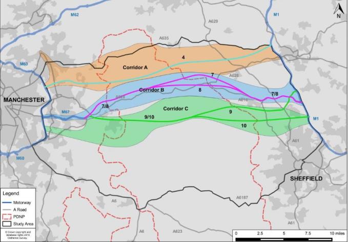
The five shortlisted routes:
Northern Corridor (A) – Crosses the PDNP at the narrowest point. To the west it extends as far north as the A627 and as far south as Ashton-under-Lyne. At the Eastern end the corridor extends towards Barnsley and the M1 in the area between the A635 and the A628 at junction 37.
A628/A616 Corridor (B) – Broadly follows the line of the existing strategic route under the PDNP following the M67, A628 and the A616. To the west the corridor broadly follows the alignment of the M67 corridor as a connection to the M60. To the East the corridor extends as far as the M1 in the area around the A616 and A61 at 35A and 36 respectively.
Central Corridor C – In the West the corridor begins near the M60 via the gap between Denton/Hyde and Romiley/Bredbury near the River Tame between junction 24 and 25. At the eastern side the corridor joins the M1 in the area of junction 35
Southern Corridor (D) – Broadly defined by the presence of Derwent Valley and Ladybower Reservoir. In the west, the corridor meets the M60 around junction 25 and also extends toward the Manchester Airport Eastern Link Road (MAELR) corridor, to the south of Manchester. At the eastern end the corridor covers the A57/A630 dual carriageway and the area to the south of Sheffield.
Overlapping Corridor (E) – Starts heading south east before turning north east and passing to the north of Stocksbridge, crossing the peak district on a diagonal. This corridor connects around J25 of the M60 and also extends toward the MAELR corridor, to the south of Manchester. In the east, the corridor extends as far as the M1 in the area around the A616 and A61 at 35A and 36 respectively.
 Powered by Wakelet