


LIVERPOOL has the least green space of any of Britain’s major cities, a new study of satellite images from space has revealed.
The revelation comes as the city prepares to sacrifice large chunks of Sefton Park and the Calderstones/Harthill estate for luxury private housing developments.
It also follows reports that Liverpool has been named and shamed for the level of traffic pollution, with calls for more tree cover in polluted cities to help soak up potentially killer particulates from exhaust fumes.
Mapping company Esri UK analysed images from the Landsat 8 satellite last springtime, zooming in on 10 British cities with the largest populations. Of the 10, Liverpool has the least green space, accounting for just 16.4 percent of the city area. In contrast almost half of Edinburgh (49.2 percent) was green space.
Esri said the results showed that the amount of green space in British cities varied widely, with some have three times more space than others.
Campaign group Sefton Park Meadows immediately seized on the findings, saying: “Conclusion, Liverpool cannot afford to lose any green space under any circumstances.”
A controversial scheme at Calderstones for half-million pound homes by Redrow is due to come before the council’s planning committee within weeks.
It will remove a large slice of the Harthill Estate, with a road cutting through part of Calderstone’s Park off Harthill Road.
The council insists that the land it has earmarked for the Redrow homes is not open to the public so is therefore not parkland.
However, users of the disabled riding stables, the Calder Kids centre and the 75 years old miniature railway, which will all disappear under the plans, are members of the public.
Even so the scheme will take away a large chunk of green space and potentially many trees.
Following top-spot Edinburgh with its 49.2 percent of greenery came Glasgow with 32 percent. The rest of the chart sees Bristol (29 percent), Birmingham (24.6 percent)) and Greater London (23percent)) came next.
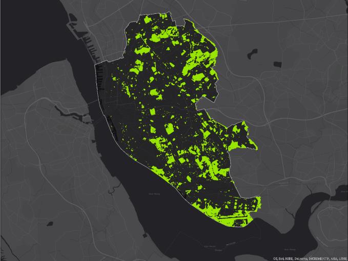 Rock and a hard place: Mapping company Esri UK puts Liverpool bottom of the league for green space at just 16.9 percent
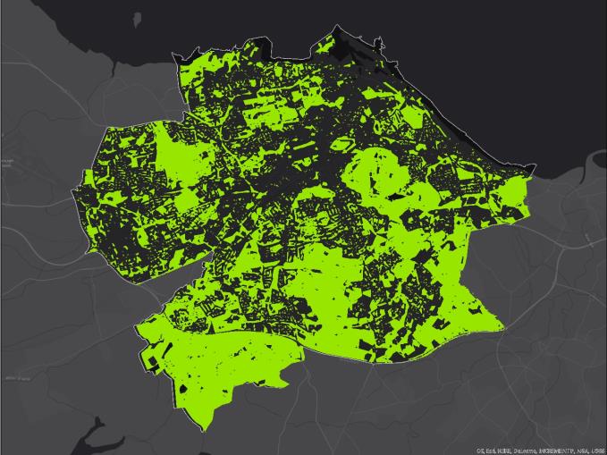 Bonny Scotland: 42.9 percent of Edinburgh is green and 32 percent of Glasgow
Liverpool, once famed for its Victorian Parks, was shown to have the least of the 10 cities , with only just over a sixth of its land classified as green space.
The other cities included in the list are Sheffield (22.1percent), Leeds (21.7 percent), Manchester (20.4 percent) and Bradford (18.4 percent).
A spokesman for Esri UK said: “The analysis was carried out by Esri UK using freely available Landsat 8 satellite imagery from spring 2016 and analysed with the organisation’s image analysis tools, using the industry standard NDVI (Normalised Difference Vegetation Index), to calculate the percentage of green space in each city.
“The NDVI is an index that uses the visible and near-infrared bands of the electromagnetic spectrum, to assess whether land mass contains live green vegetation or not. Often used to monitor drought, predict farming output or to help predict hazardous fire zones, the NDVI is preferred for global vegetation monitoring because it helps compensate for changing illumination conditions, surface slope, aspect and other unrelated factors.”
Esri UK is a mapping software company which counts the Environment Agency, Scottish Power and Defra amongst its customers.